This project started in 2018 and has been a wonderful collaboration between Landowners, NZ Landcare Trust, Tasman District Council, Tasman Environmental Trust, Project Mohua, Manawhenua ki Mohua, Fonterra, Project De-Vine, Takaka Primary School and the community.
The Motupipi River is a small, spring-fed river that flows beside the township of Takaka and out to the Motupipi estuary. The river was obstructed by crack willows in several places and dense aquatic weed, with deep sediment build-up in many areas.
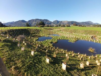
Over the last five years the crack willow has been poisoned in the whole catchment. There is ongoing work to remove any regrowth. Tributaries are having wetlands reinstated and the streams have been restored to a more natural, meandering flow. Many landowners have moved fences back and riparian planted thousands of new trees and native plants on their farms.
Tasman District Council tackled the most impacted reach of the river and removed a significant volume of sediment, re-meandered the stream, created artificial instream habitat structures and planted the banks. A new strip of land was purchased and there is now a public walkway along some of the river bank east of Takaka township.
It is hoped that as the habitat is restored it will again support thriving populations of freshwater fish, as well as birds and other treasured species. Pukatea trees are making a comeback in this lowland river too as once they would have been abundant here.
Farmers and Council are continuing restoration work in this catchment.